Chapter 7: Lake-Aquifer Interaction
The chapter commences with a comprehensive review of the literature and theory of lake-aquifer interaction. Flow-through lakes receive and release water over different parts of the lake bed. They represent the mid point in a continuum from recharge lakes (which release water to the aquifer over the entire lake bed) to discharge lakes (which receive groundwater over the entire lake bed). Using a network of 15 piezometers and 25 water table observation wells weekly flow nets were generated. These demonstrated how Perry Lakes oscillate between flow-through and recharge status in response to storm water inputs, artificial summer level maintenance and local groundwater extraction for lawn irrigation.
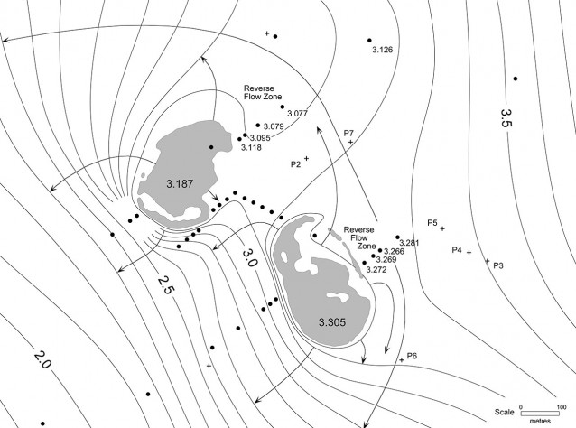
June 02, 1997. Typical flow regime following heavy rain (73mm over 3 days) and storm water inputs. Both lakes are mounded and recharging lake water back to the unconfined aquifer. This was an extreme case where the lakes share a common release zone. Black circles are monitoring wells, + symbols are irrigation bores. West Lake at top, East Lake at bottom. Figures in each lake are water surface height (m) above datum.
As winter rains set in, flow-through regimes become established in both lakes. Initially the capture and release zones for each lake are separate. As the water table reaches its winter maximum the capture and release zones merge.
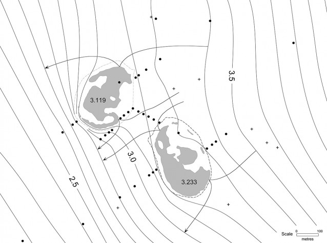
August 04, 1997. Typical early winter flow pattern. Flow-through regimes are established in both lakes with separate capture and release zones. Storm water inputs from storm drains have already mounded the lakes.
In a flow-through lake a ‘dividing stream line’ marks the boundary between the section of the lake bed receiving groundwater discharge and the section where lake water is being recharged back to the unconfined aquifer. In the example above, the dividing stream line runs through each lake with end points where the up gradient capture zone flow lines enter the lake and the down gradient release zone flow lines exit the lake. Notice that the position of the dividing stream line tends towards the up gradient side of each lake. This occurs because storm water inputs are constantly pushing the lake towards recharge. The area of the lake bed recharging water back to the unconfined aquifer is much greater than the area of the lake bed receiving discharge from the aquifer.
Chapter 7 also details field experiments conducted during the approach to summer 1997-1998. As the rains diminished the local unconfined aquifer began declining and East Lake began shrinking. Under an agreement with the wetland managers the lake was allowed to approach complete dryness before summer top up maintenance commenced. Using mini piezometers installed around the lake margin it was possible to document on a daily basis changes in the position of the dividing stream line. The theory behind this experiment is shown in the following diagram.
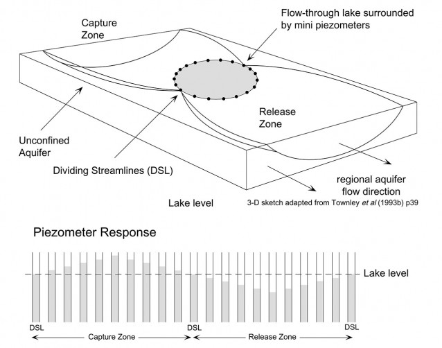
In a flow-through lake the dividing streamlines occur where the piezometric head is equal to the lake surface. If piezometers are installed around such a lake, their response will defined by positive piezometric heads in the capture zone and negative piezometric heads in the release zone.
The mini piezometers were monitored over two months. The piezometers were read (and often relocated) on a daily basis to follow both the position of the dividing streamline and the receding shoreline as East Lake approached dryness. Using a small hand operated sludge pump, a mini piezometer could be installed in about 5 minutes. They were always installed in the lake just a few metres from shore. Using the lake surface as a datum, positive or negative piezometric heads could be observed and measured quickly. Typical data from the experiment are shown below.
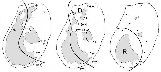
Individual mini piezometers are shown as dots, with piezometric heads indicated as positive or negative relative to the lake surface level. On November 16 East Lake is still weakly mounded (the result of late season rain and storm water inputs. The dividing stream line is located close to the up gradient side of the lake. The lake is in flow-through but tending towards recharge. The integrated balance for the period November 11-22 confirms this. Recharge to the aquifer was 1850 m³ while groundwater discharge into the lake was just 270 m³. In December the lake shrinks further and leaves small remnant ponds. Initially these displayed positive piezometric heads around their entire periphery and acted as small discharge lakes. Eventually flow-through conditions became established in some ponds. The lake shrank to almost total dryness and the wetland managers commenced artificial summer maintenance December 20. Under these conditions the lake is permanently mounded above the water table. Lake water is recharged back to the aquifer over the entire lake bed.
Chapter 7 concludes with a discussion of the practical issues surrounding artificial lake level maintenance on the Swan Coastal Plain. By way of example, we were able to demonstrate that at Perry Lakes the hydraulic conductivity of the lake lining doubles over summer when lake water temperatures can reach 40 deg. C. For wetland managers struggling to maintain water levels over summer, the cards are stacked against them. The lake is the visible top of a local groundwater mound which pumping attempts to maintain against a falling regional water table, locally depressed further by pumping, increased transpiration and open water evaporation. The rate of mound decay is further enhanced by reduced water viscosity and higher effective lining hydraulic conductivity.
