Chapter 3: Physiology
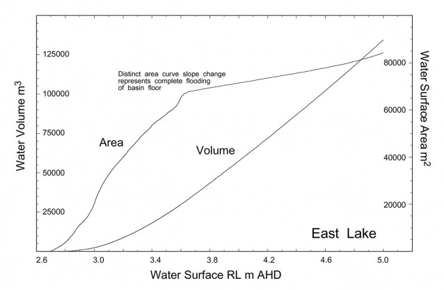
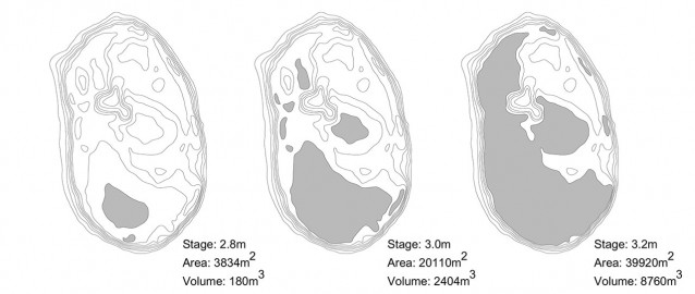
A summary of all the basic physical and biological characteristics of Perry Lakes. There is particular emphasis on the requirement for accurate depth-water surface area-volume curves when computing the mass, solute, isotopic and thermal balances. Due to their shallow depth (aided by much reduced area in summer) a grid of survey points marked by wooden pegs was established on 10×20 metre centres over each lake. Traditional optical levelling was used to measure each point to +/- 1mm accuracy, tied to government survey bench marks. At any lake stage (read to 1mm accuracy) a corresponding water volume and surface area could be generated.

The accurate relationship between water surface height (tied to a local topographic survey datum), water surface area and volume is essential for computing not just mass but also solute and isotopic balances. Surface area is essential for computing direct input from rainfall and evaporative loss. In thermal balances area is used in computing incoming and reflected short and long wave radiation, long wave radiation emitted from the water and heat in rain falling directly on the lake. At Perry Lakes the lake basin topography was determined in detail using a traditional grid of survey pegs and optical levelling. In East Lake (area 5.2ha) a total of 1080 individual surveyed points was used to accurately define the lake basin. Engineering software (originally designed to calculate open cut mine area and volume) was used to compute lake surface area and volume from dryness in 1mm lake stage increments. Such attention to accuracy was essential. Perry Lakes are very shallow basins. Small changes in lake stage produce large changes in water surface area.
Perry Lakes are considered to be Holocene features, formed when sea level stabilised and climate approached modern era conditions about 8,000 years B.P. The extent and thickness of the clay lining was mapped in both lakes using simple probing equipment. In East Lake this clay lining is in excess of 3m thick. Undisturbed core samples were extracted and lining stratigraphy correlated with Holocene data for the Swan Coastal Plain.
The geology and hydraulic conductivity of the local unconfined aquifer was investigated using extensive sieve analysis of drill samples plus pump and specific capacity tests. In situ undisturbed cores of lake basin sands and clay were extracted in large diameter PVC pipe and these pipes then used as permeameters to determine vertical hydraulic conductivity and specific yield (necessary for transpiration experiments). The unconfined aquifer is known to be far from uniform geologically. Piezometers drilled specifically for this study were probed with natural gamma and EM39 to map limestone, sand and calcrete associated with palaeo water tables.
Detailed botanical mapping was completed at West Lake over February 1995, 1996 and 1997. West Lake first dried out over summer 1995. The mapping confirmed that fringing emergent macrophytes constitute extremely dynamic plant communities which respond quickly to modified water regimes.


