Chapter 13: Climate, Urbanisation and Wetlands
This chapter examines the issue of declining water levels which have plagued the wetland managers at Perry Lakes since the 1960’s. Perry Lakes of course is part of the Perth metropolitan area and water level problems need to be evaluated within the larger context of a rapidly expanding city and issues such as global warming and long term reduced rainfall over the SW part of Western Australia. Perth has a Mediterranean climate but indulges in European temperate gardens and huge areas of lawn. This is only possible because most of Perth is a ‘Non proclaimed’ water management area. Any homeowner has the common law right to sink a private bore and extract groundwater with no licence or requirement to notify any government authority or requirement to metre the amount of water withdrawn. There are probably somewhere between 150,000 and 200,000 private bores in the metropolitan area.
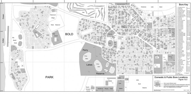
Regional water balance models were constructed for an area of about 9 square km around Perry Lakes. All groundwater extraction bores in the area were mapped. This included bores installed by private home owners and larger bores in parks and reserves, university grounds etc. The models confirm that the average 50mm annual decline in the water table observed over the past 40 years is entirely consistent with the imbalance between extraction and recharge. The models suggest that under prevailing rainfall conditions of 700mm per year bore extraction may have exceeded recharge by about 550,000m³ an amount equivalent to 220 Olympic size swimming pools in the small model area alone and equating to a 50-60mm annual water table decline.
As far as we are aware the bore mapping project is the only one of its kind ever attempted in the Perth metropolitan area. The final map is included for download within Chapter 13 as three A4 PDF pages. The entire map can also be viewed in reduced detail below (click to enlarge).


